

Businesses often know what assets they own but cannot always answer a more urgent question:
Where are those assets right now?
A hospital may need to locate a mobile medical device. A factory may need to find a tool, container, forklift, or work-in-process item. A warehouse may need to know whether a pallet has entered the correct zone. An airport may need to track ground-support equipment, while a logistics company may need visibility across indoor facilities and outdoor transportation routes.
A real-time location system, commonly abbreviated as RTLS, helps organizations identify the current or most recently detected location of assets, inventory, equipment, vehicles, or people.
RTLS is not one specific wireless technology. It is a category of location solutions that can use RFID, Bluetooth Low Energy, ultra-wideband, Wi-Fi, GPS/GNSS, infrared, ultrasound, or a combination of technologies. The right RTLS design depends on the required coverage, accuracy, update frequency, infrastructure, tag cost, battery life, and operating environment.
RTLS stands for Real-Time Location System or Real-Time Locating System.
An RTLS solution collects location-related data from tagged objects or devices and presents that information through software.
Depending on the application, RTLS may tell users:
“Real time” does not always mean that the location changes every millisecond. Some applications only need a timestamp when an asset enters or exits a defined area. Other applications require frequent coordinate updates and precise continuous movement tracking.
The required level of visibility should be defined before selecting the technology.
GPS is one technology that can support real-time location tracking, particularly outdoors. RTLS is the broader system category.
A GPS-enabled fleet platform can therefore be considered a type of RTLS, but not every RTLS solution uses GPS.
Indoor facilities often require other technologies because satellite signals may be weak or unavailable inside buildings. Technologies such as RFID, BLE, UWB, Wi-Fi, infrared, and ultrasound can provide indoor or zone-level location visibility.
A simple distinction is:
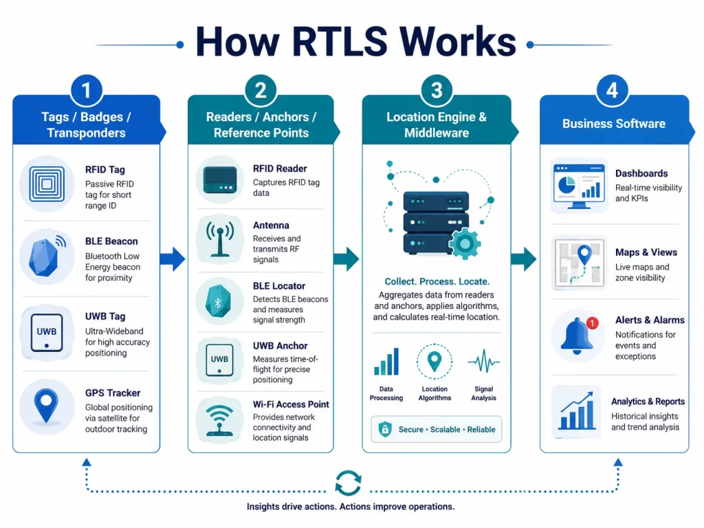
Although RTLS architectures vary, most systems contain four main layers.
A tag or transponder is attached to the object or person that needs to be located.
Examples include:
The tag carries a unique identifier. Depending on the technology, it may wait for a reader signal, broadcast periodically, or communicate with fixed anchors.
Fixed infrastructure detects signals from the tags.
Depending on the RTLS technology, this infrastructure may include:
These devices collect tag information and forward it to the location platform.
The location engine converts signal data into usable location information.
It may use:
Middleware can filter duplicate reads, combine data from multiple devices, apply business rules, and send useful events to another application.
RTLS software displays and uses the location information.
It may provide:
The location itself is only the starting point. The real business value comes from turning location data into alerts, decisions, and automated workflows. Zebra describes this final layer as using location intelligence to improve business processes and operational decisions.
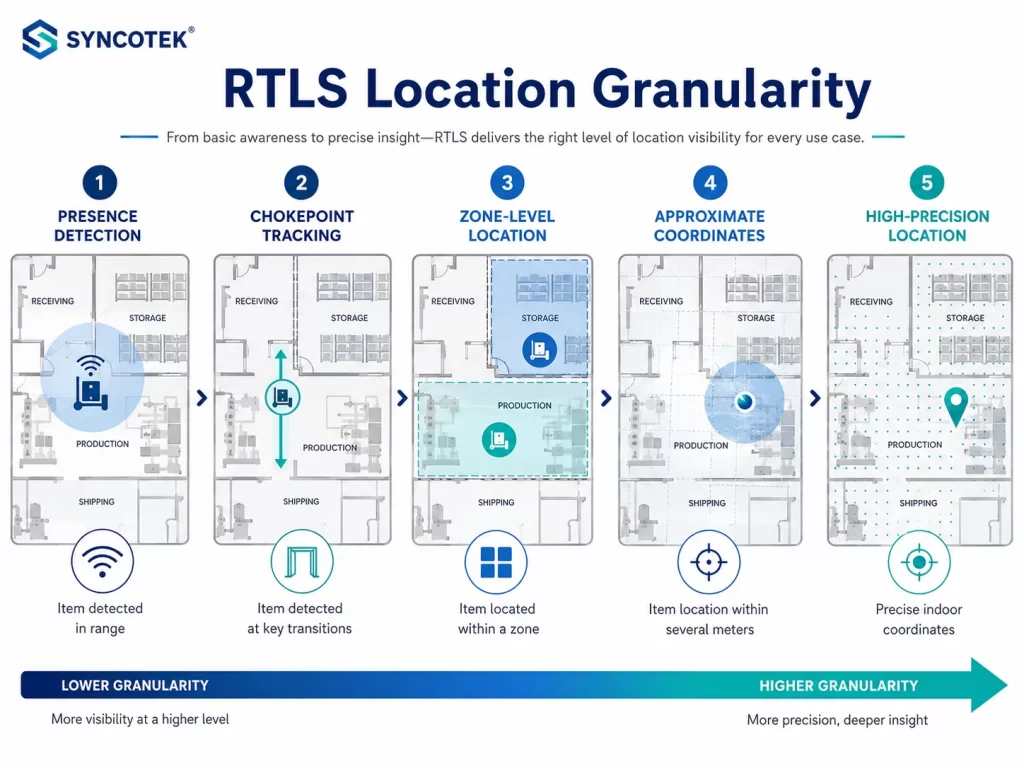
RTLS systems can provide several levels of location visibility.
The system confirms that an asset is present within reader range.
Example:
This is the simplest location level.
The system records when an item passes through a controlled point.
Common chokepoints include:
Chokepoint tracking does not continuously calculate exact coordinates. Instead, it records movement between known zones.
This approach is often practical because it focuses infrastructure on operationally important locations.
The system identifies the room, department, production area, or storage zone containing the asset.
Examples include:
Zone-level RTLS may be sufficient when the goal is to reduce search time or confirm process movement.
The system estimates the asset’s position within a defined space.
The software may show the asset on a building map with an approximate location rather than only identifying a room or zone.
Accuracy depends on:
High-precision RTLS continuously calculates coordinates with significantly finer accuracy.
This may be required for:
UWB commonly uses time-of-flight measurements between devices and fixed anchors. The FiRa Consortium explains that its wide bandwidth and short pulses can support centimeter-level positioning under suitable system conditions.
There is no universally best RTLS technology. Each option has different strengths, costs, accuracy levels, and infrastructure requirements.
RFID-based RTLS can use passive RFID, active RFID, or a hybrid design.
Passive UHF, also known as RAIN RFID, uses battery-free tags that receive power from the reader’s radio signal.
It is commonly used for:
Passive UHF tags are relatively small and can be deployed in large quantities. Readers may be fixed or handheld and can read, write, and authenticate compatible tags. Impinj lists a typical maximum UHF RFID read range of up to approximately 10 meters, although actual performance depends on the tag, reader, antenna, item material, and environment.
Passive RFID is often a strong option when the business needs to identify many items economically but does not require constant high-precision coordinates.
For warehouse and stock applications, passive RFID can be combined with RFID inventory management workflows.
Active RFID tags contain their own battery and periodically broadcast a signal.
They may provide:
Active tags are usually larger and more expensive than passive RFID tags. Battery management must also be included in the lifecycle plan.
BLE RTLS uses battery-powered Bluetooth beacons or tags with fixed receivers or locators.
BLE is commonly used for:
Basic BLE systems may estimate position using received signal strength. More advanced Bluetooth Direction Finding systems use angle-of-arrival or angle-of-departure techniques to improve location determination. Bluetooth SIG introduced direction-finding features specifically to enhance proximity and positioning services.
BLE can be attractive when organizations already use Bluetooth-enabled devices or need flexible battery-powered tags.
Ultra-wideband is commonly selected when precise indoor positioning is required.
UWB can support:
UWB calculates distance using signal travel time rather than relying only on signal strength. It normally requires UWB tags or devices and a network of anchors.
Its main strengths are accuracy and rapid positioning. Its tradeoffs may include higher tag and infrastructure costs compared with simpler zone-based RFID or BLE systems.
Wi-Fi location systems use wireless access-point infrastructure to detect compatible tags or devices.
Potential applications include:
Wi-Fi may reduce the need for completely separate infrastructure when access points are already available. However, network coverage designed for data communication is not automatically optimized for accurate positioning.
A location survey and system calibration may still be required.
GPS and other GNSS technologies are best suited to outdoor and wide-area tracking.
Common applications include:
GPS provides broad geographic coverage but may not perform reliably inside warehouses, hospitals, factories, tunnels, or dense urban structures.
Many companies therefore use a hybrid solution:
Infrared and ultrasound technologies can support controlled indoor positioning.
Infrared may be useful for room-level visibility because signals generally do not pass through walls in the same way as radio signals.
Ultrasound can use sound travel characteristics to estimate indoor position.
These technologies may be selected for specialized environments but usually require dedicated receivers and careful installation.
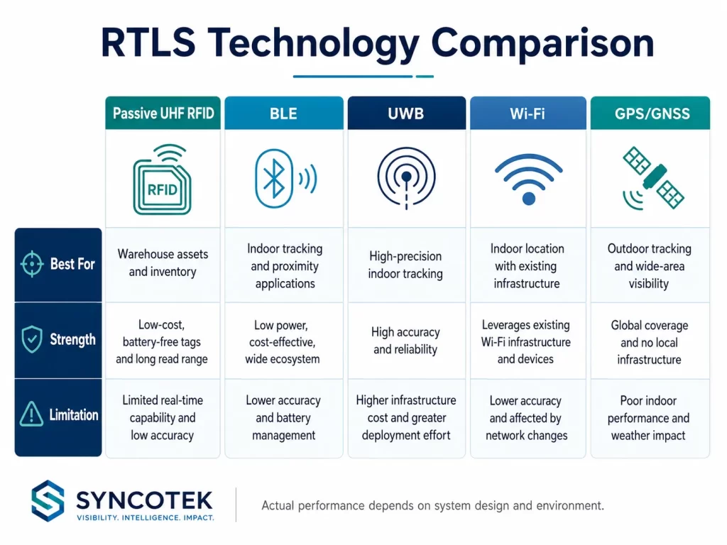
| Technology | Typical Location Level | Main Strength | Main Limitation | Common Applications |
|---|---|---|---|---|
| Passive UHF RFID | Presence, portal, zone, approximate position | Low-cost battery-free item tags | Requires reader coverage; not always continuous | Inventory, tools, WIP, pallets, assets |
| Active RFID | Room or zone-level tracking | Longer range and regular broadcasts | Battery and tag cost | Healthcare, mining, industrial assets |
| BLE | Proximity, room, zone, approximate coordinates | Common ecosystem and flexible beacons | Accuracy depends heavily on design | Staff, visitors, equipment, wayfinding |
| UWB | High-precision coordinates | Precise ranging and movement data | Higher infrastructure and tag cost | Vehicles, safety, automation, precise assets |
| Wi-Fi | Zone or approximate coordinates | Can use enterprise network infrastructure | Existing network may need optimization | Campuses, hospitals, mobile devices |
| GPS/GNSS | Outdoor geographic coordinates | Wide outdoor coverage | Weak indoor performance | Fleets, containers, vehicles |
| Infrared | Controlled room-level location | Strong room boundary control | Requires line of sight or dedicated coverage | Healthcare and specialized facilities |
| Ultrasound | Indoor room or coordinate location | Controlled indoor positioning | Dedicated infrastructure required | Healthcare and specialized industrial systems |
These descriptions are general. Actual performance depends on system design, product specifications, installation conditions, tag orientation, software, and environmental interference.
RTLS and RFID are not competing terms.
RFID is a technology. RTLS is a system objective.
Passive RFID can be part of an RTLS solution when readers and antennas are used to determine:
Passive RFID is often suitable when:
A UWB or active RFID system may be more suitable when:
The correct choice should be based on the business requirement, not on the assumption that higher accuracy is always better.
Inventory tracking answers questions such as:
RTLS adds location-oriented questions:
An RTLS platform may therefore include inventory functionality, but its main value is location and movement visibility.
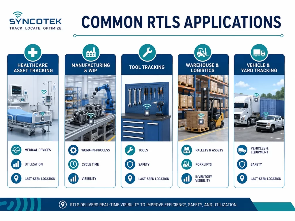
Hospitals frequently need to locate:
RTLS can reduce time spent searching for equipment and help staff understand availability, utilization, maintenance status, and last-seen location.
Manufacturers can use RTLS to track:
Location data helps identify process bottlenecks, missing materials, incorrect routing, and excessive dwell time.
RTLS may be integrated into a broader RFID in manufacturing deployment.
Tools are frequently moved between storage rooms, workstations, vehicles, and job sites.
An RTLS or zone-tracking system can provide:
For detailed implementation considerations, see Syncotek’s guide to RFID tool tracking.
RTLS can support:
A lower-cost passive RFID design may focus on portals and chokepoints. Higher-precision systems may continuously locate vehicles or handling equipment.
RTLS badges or wearable devices can help support:
Personnel tracking requires careful privacy, consent, data-security, and labor-policy planning.
RTLS technologies may be used to monitor:
The system should collect only the data necessary for the event’s operational purpose. Syncotek’s RFID attendee tracking guide explains event-specific implementation considerations.
Outdoor and mixed-environment RTLS can help locate:
Hybrid GPS, cellular, RFID, BLE, or UWB designs may be required when assets move between outdoor yards and indoor facilities.
Employees can search for an asset through software instead of walking through facilities or calling multiple departments.
Location and usage history can reveal whether equipment is:
Organizations may avoid unnecessary purchases when existing equipment can be located and redistributed.
RTLS can reveal:
Last-seen information, exit monitoring, and zone alerts help teams investigate missing or unauthorized asset movement.
The system can connect location with:
High-precision RTLS may support collision warnings, restricted-zone detection, emergency response, and worker mustering.
Historical location information can support:
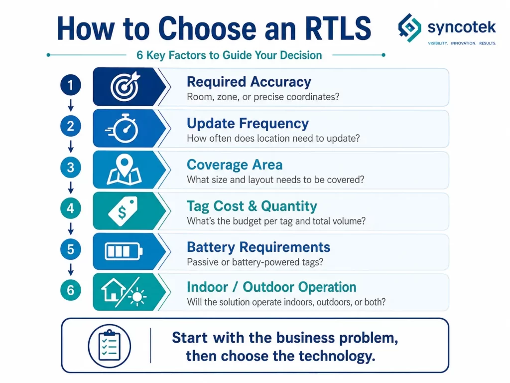
Start by defining what “location” means for the application.
Do you need:
Choosing more accuracy than the application needs can increase cost and complexity without creating additional value.
Determine how often the location must update.
Examples:
Higher update frequency may affect battery life, network traffic, infrastructure, and software processing.
Define whether the system must cover:
A company tracking thousands or millions of low-value items may require inexpensive passive tags.
A company tracking a smaller number of vehicles, medical assets, or high-value tools may accept more expensive active or UWB tags.
Passive RFID tags do not require batteries. BLE, active RFID, GPS, and many UWB tags normally require a power source.
For battery-powered tags, review:
GPS may work well outdoors but poorly indoors. Indoor technologies may provide better building-level visibility but limited geographic coverage.
A hybrid architecture may be required for assets that move between both environments.
Consider:
For RFID-based RTLS, the tag, antenna, and installation layout must be tested on the actual asset.
Metal equipment may require specialized mount on metal RFID tags.
Determine whether the organization can reuse:
Existing infrastructure may reduce deployment cost, but it should not be assumed to provide the required positioning performance without testing.
The RTLS platform may need to connect with:
When RTLS tracks people or sensitive assets, the project should define:
Start with a measurable operational problem.
Examples:
Choose the minimum useful level:
Document:
Evaluate RFID, BLE, UWB, Wi-Fi, GPS, and hybrid options against:
For RFID-based deployments, reader and antenna placement determines what the system can detect.
Review:
Syncotek’s guide on how to select the right RFID antenna provides additional guidance for controlled RFID zones.
A pilot should use:
Measure outcomes such as:
After validating the pilot:
Choosing UWB, BLE, or RFID before defining the operational need can create an expensive solution that provides unnecessary data.
Many successful RTLS projects use portals, rooms, or zones rather than precise map coordinates.
The asset’s size, material, movement, environment, and available tag position can have a major effect on performance.
Readers, anchors, network connections, mounting, electrical power, cabling, servers, and software integration may represent a significant part of total project cost.
For fixed RFID infrastructure, suitable RFID cables, connectors, and adapters are required to maintain reliable reader-to-antenna connections.
A technically accurate system may still fail if users cannot search assets easily, respond to alerts, maintain tags, or integrate data into daily workflows.
Laboratory performance does not guarantee reliable operation in a hospital, factory, warehouse, or outdoor yard.
Before choosing a real-time location system, confirm:
RTLS is a broad category of systems used to identify and locate assets, equipment, inventory, vehicles, or people in real time or near real time.
An RTLS may use passive or active RFID, BLE, UWB, Wi-Fi, GPS/GNSS, infrared, ultrasound, or a hybrid architecture. Each technology provides a different balance of accuracy, coverage, cost, tag size, infrastructure, battery life, and update frequency.
The best RTLS is not automatically the system with the highest accuracy. It is the system that provides enough location visibility to solve the business problem reliably and economically.
For applications based on presence, portals, rooms, and process zones, RFID can provide a scalable approach using tagged assets, fixed or handheld readers, antennas, and software. For continuous high-precision coordinates, UWB or another precision-location technology may be more suitable.
A successful project starts by defining the workflow and required location level before selecting the technology.
RTLS stands for Real-Time Location System or Real-Time Locating System. It is a system used to identify and locate assets, equipment, inventory, vehicles, or people.
No. RTLS is the overall location solution. RFID is one technology that can be used to build an RTLS.
Yes. GPS or GNSS can support RTLS for outdoor vehicles, containers, equipment, and other geographically distributed assets.
Yes. Indoor RTLS commonly uses RFID, BLE, UWB, Wi-Fi, infrared, ultrasound, or hybrid technologies.
Accuracy varies widely. Some systems provide doorway or room-level location, while high-precision UWB systems may provide much finer coordinate positioning. Actual accuracy depends on the technology and installation.
Not always. Passive RFID uses battery-free tags. BLE, active RFID, GPS, and many UWB tags normally require batteries or another power source.
Zone tracking identifies the room or area containing an asset. Coordinate tracking estimates its position on a map using x-y or x-y-z coordinates.
Yes. Passive RFID can support presence detection, portals, chokepoints, zone tracking, last-seen location, and some approximate positioning applications.
There is no single best option. The right technology depends on required accuracy, range, update frequency, tag quantity, cost, environment, battery requirements, and software integration.
RTLS is used in healthcare, manufacturing, warehousing, logistics, mining, construction, aviation, retail, hospitality, events, transportation, and many other industries.
Need RFID Hardware for Asset Location and RTLS Projects?
Syncotek provides RFID readers, reader modules, antennas, tags, handheld devices, and related system components for inventory visibility, asset tracking, manufacturing, tool management, logistics, access control, and real-time location applications.
Whether your project requires passive RFID portals, zone-level asset detection, handheld location searches, fixed reader infrastructure, or RFID module integration, Syncotek can help evaluate suitable components based on your asset type, read range, coverage area, operating environment, and software workflow.
Explore Syncotek’s complete RFID products for your RTLS and asset-location project.
 Knowledge
Choosing an RFID printer is not just about buying a machine that can print labels. In real deployments, the printer, RFID labels, inlay position, ribbon, application environment, and encoding workflow all have to work together. If any one of those elements is mismatched, you can end up with failed encoding, poor print quality, wasted labels, […]
READ MORE Knowledge
An RFID system may work perfectly during initial testing and then behave very differently after it is installed in a warehouse, factory, smart cabinet or production line. Common symptoms include: tags read intermittently expected read distance becomes shorter several tags on a pallet are consistently missed tags outside the intended area are detected a system […]
READ MORE Uncategorized
Passive UHF RFID tags can communicate without a battery, cellular connection, Wi-Fi radio, or conventional transmitter. This is possible because the tag does not generate a completely independent radio signal. Instead, it receives energy from an RFID reader, powers its integrated circuit, and changes how much of the reader’s RF energy is reflected back. This […]
READ MORE Knowledge
When companies start working with RFID, they often search for a dedicated RFID writer. The goal is usually simple: write data to RFID tags so the tags can identify products, assets, cartons, tools, or inventory items in a digital tracking system. In real RFID projects, however, the term “RFID writer” can be confusing. Many modern RFID […]
READ MORE Knowledge
When businesses start planning an RFID project, they often focus on readers, antennas, and software first. However, one of the most important decisions is the RFID item attached to the object being tracked. This is where terminology can become confusing. Many people use RFID inlay, RFID tag, and RFID label interchangeably. In some conversations, this may not cause a […]
READ MOREIf you are interested in our services or need customized solutions, please feel free to contact us.